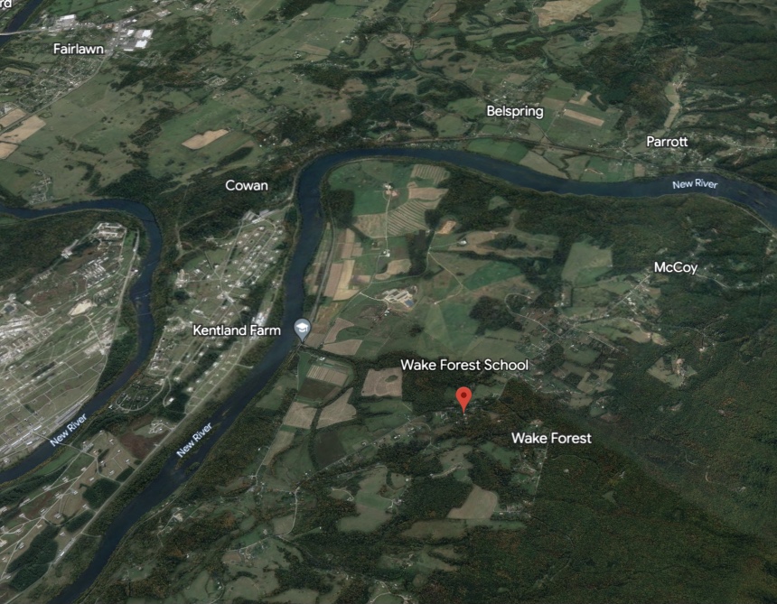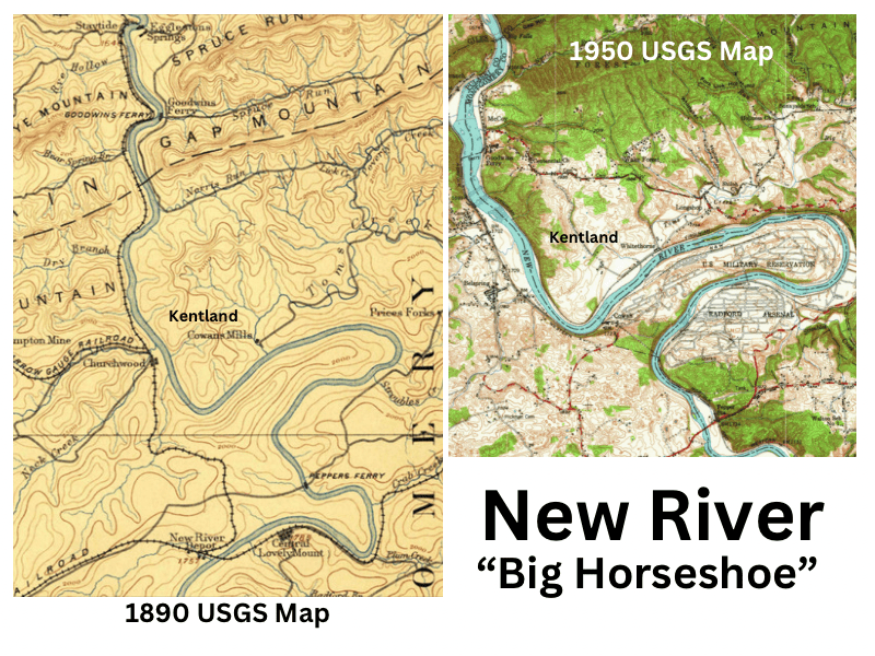
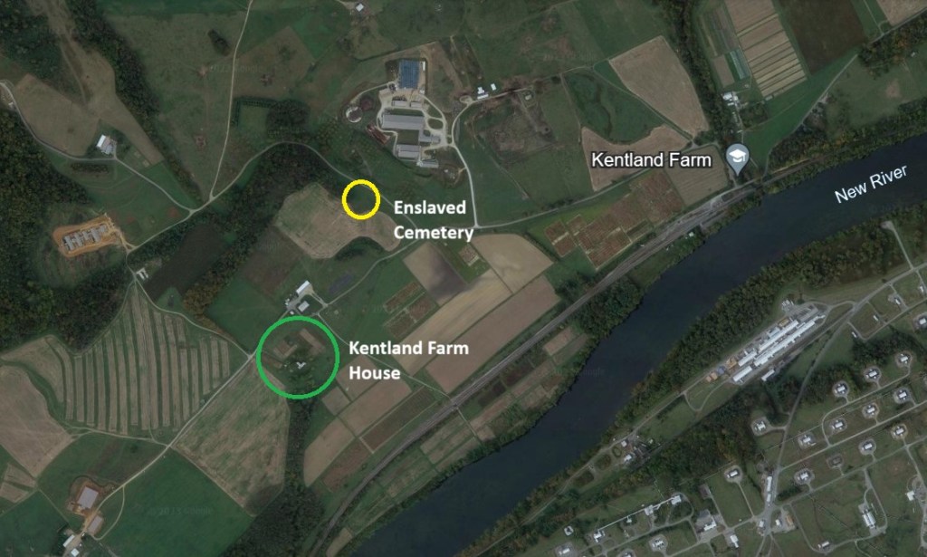
Historic Kentland Farm lies on a distinctive horseshoe bend of the New River, at the mouth of Toms Creek, nestled between Brush Mountain and the river. Since the 1940s, the Radford Army Ammunition Plant has dominated the viewshed, occupying the interior of the bend. Archaeological evidence and historical records trace human presence in this area—once known as “Horseshoe Meadow”—to well before European settlement.
Patricia Givens Johnson’s Kentland at Whitethorne (1995) provides a detailed history of the area. For centuries, the land along the New River served as a crucial corridor for wildlife and Indigenous people, who followed the river and used its natural ford. A village once stood on both sides of the river, with a burial ground near the mouth of Toms Creek. This site was destroyed in the 1880s during the construction of the Virginian Railway.
Early European Exploration
European explorers pushed westward 64 years after the founding of Jamestown. In 1671, Thomas Batte (1630s–1690s) and Robert Hallom (or Hallam, sometimes spelled with an “F” in early records) explored the region with guides along their way from the Appamattuck, Saponi, and Totero tribes. Thomas Woods began the journey with the two men, but fell ill and died near what is now Charlotte Courthouse. Their accounts describe traveling northwest to the horseshoe bend before continuing over the Appalachians to Tug Fork, following the Woods River—later named the New River—until it emptied into the Ohio River.
Wood, Bates, Jones, and Evan families, early traders with Indigenous groups, referred to “Jones Creek” in early documents—the same waterway later known as Toms Creek. This creek, draining much of Brush Mountain’s southern watershed, flows into the New River at the northern loop of the horseshoe. Johnson speculates that the creek was named for Thomas Jones, grandson of General Abraham Wood.
Early European Settlers
By 1745, hunter Robert Lorton and fur trader Jeremiah Pate were living along Toms Creek and the “Big Horseshoe.” Around the same time, the Harmon (Harman) family from Germany (Adam, Jacob & Valentine), also hunters and traders, set up a claim and settled in the area.
Land speculator, James Patton hired John Buchanan to survey 100,000 acres, (land associated with the Clinch, Holston and New River) including the Big Horseshoe. In October 1745, Buchanan recorded in the Woods River entry book that Adam Harmon was living there. A 1750 land survey noted that Harmon “maintained a convenient ford at the lower end of Harman’s Bottom on the horseshoe of the New River” (Noble, 2009).
“Horse Shoe Bottom” was particularly prized for its fertile, relatively flat river terraces. According to Johnson (1995), early on Adam Harmon owned 985 acres along Toms Creek, including the mouth to the Woods River (the New). Patton’s land holdings included the Horse Shoe Bottoms—both “Big” and “Little” (now part of the Radford Arsenal, on the lower terraces north of the river bend)—as well as areas surrounding Harmon’s claim along Toms Creek. By 1747, Patton’s agent, Israel Lorton, had sold these tracts, primarily to German families such as the Harless, Long, Price, and Wall families who moved to the area. On November 7, 1752, Harmon received a land patent, but he and his family forfeited their claim after failing to make the required improvements, that land reverting back to Patton.
Anglo-French & Indigenous War or Seven Year’s War
The Seven Years’ War made the region perilous for European settlers, who were viewed as unwelcome intruders. Despite the violence and personal losses, the Harmon family chose to stay, unlike many of their neighbors who sought safety by moving east of the Allegheny Mountains. In 1756, Jacob Harmon and one of his sons were killed, followed by Valentine Harmon’s death the next year. Adam Harmon participated in the war, notably serving under Captain Robert Wade in the Sandy Creek campaign, 1758. He later died along the New River in 1767.
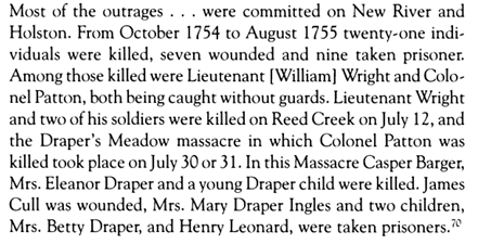
However, as Shawnee attacks intensified, most of these families, except Adam Harmon, abandoned their claims. Their failure to pay quitrents to James Patton’s estate – Colonel Patton died at Draper Meadow in 1755 – resulted in forfeiture. John Buchanan then took possession of the Price and Harless lands. In 1757, these families sued Buchanan but lost, allowing him to retain ownership of the Big Horse Shoe and the land along Toms Creek.
According to Johnson (1995), Harmon’s Fort, also known as Fort Maynard, was built in 1763, likely to protect the ford amid increased attacks during Pontiac’s War. During this period, settlers were ordered to retreat east of the Allegheny Mountains under the King’s Proclamation of 1763. With taxes on Adam Harmon’s land at the mouth of Toms Creek left unpaid, John Buchanan claimed the property for James Patton’s estate and eventually took possession. His accumulated landholdings was called Buchanan’s Bottoms.
John & Margaret Patton Buchanan
John Buchanan married James Patton’s daughter, Margaret, in June 1749. They initially lived near Max Meadows but later moved east to Reed Creek to escape danger. Together, they raised three sons—James, William, and John—and four daughters. When John Buchanan Sr. passed away in 1769 at Greenfield, the home of William Preston in Botetourt County, the Buchanan’s Bottom tract encompassed 500 acres. Adam Harmon’s former land was given to John Buchanan Jr., who owned it until his death at the Battle of Saratoga in 1777.
According to Johnson (1995), John Smith, an early partner of John Buchanan Sr. in the Woods River Company, resided and managed Buchanan’s Bottom. He likely remaining there until John Buchanan Jr.’s death.
Abram and Susannah Ingles Trigg
In 1793, Abram Trigg purchased the land and, with the labor of the enslaved people he owned, developed it into a large working plantation. He was married to Susannah Ingles, the daughter of William and Mary Draper Ingles. Trigg studied law and became the Montgomery County Clerk of the Court in 1785. His brother, Stephen Trigg, married Mary Christian, the sister of William Christian, for whom Christiansburg, the county seat, was named.
Abram and Susannah later moved to Buchanans Bottom, where they built a log home near the current house site and raised their seven children. Trigg served in the U.S. Congress until 1809 and was Montgomery County sheriff from 1810 to 1811. Over time, he and Susannah expanded their land holdings, selling parcels to neighbors Philip Harless and Henry Harman Sr.
According to Johnson (1995), the family eventually relocated to Tennessee. In 1813, they sold their 1,630-acre plantation to Gordon, Thomas, and David Cloyd for $10,000. The Cloyds also purchased the mill on Toms Creek and a parcel of land originally granted to Jacob Shell at the southern end of the horseshoe.
Gordon and Elizabeth McGavock Cloyd
Gordon Cloyd and his wife, Elizabeth McGavock, had six children, but only two daughters, Mary and Elizabeth Cloyd, survived to adulthood. When Mary, (1800-1858), came of age, she married her first cousin, James Randal Kent (1792-1867). They shared the same maternal grandfather, James McGavock of Wythe.
James Randal and Mary Cloyd Kent
In 1818, upon their marriage, Gordon Cloyd gifted Buchanans Bottom—including the Trigg family’s log home and enslaved people—to his daughter Mary. She and her husband, James Randal Kent, lived there for the rest of their lives. Gordon’s 1833 will confirmed that the land legally belonged to Mary, not James.
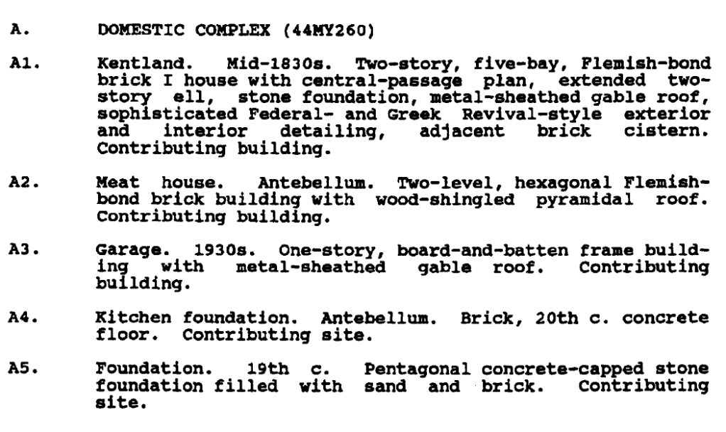
Family oral history suggests that the house dates to the 1820s and was built by John Swope, a Hessian soldier. The architectural similarities among three Cloyd homes—Back Creek, Springfield, and Kentland—support a possible connection to Swope. However, the house was more likely constructed after Gordon Cloyd’s death in 1833. Despite this, records indicate that James Kent had carpenters and stonemasons actively building during the summer of 1819.
Johnson (1995, pp. 30–33) provides extensive details on the house’s design and construction, highlighting the unique feature of a spring located beneath the structure. The National Register of Historic Places Registration Form, dated July 3, 1991, includes a description of the house based on Patricia Givens Johnson’s research.
The Kent family amassed significant wealth through their land, the labor of enslaved people, and the complex economy of securing loans and financial transactions. They owned a grist mill near the mouth of Toms Creek and operated a millstone quarry on their property, producing high-quality French Burr stones that were used locally, sold abroad, and remained a valuable resource into the 1940s.
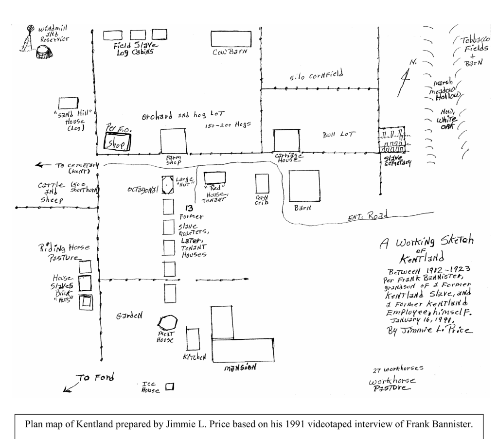
By 1860, James Kent, now a widow, had amassed 8,000 acres of land and enslaved 123 people, who were forced to labor on the plantation and support his extensive grain and cattle business. Historian Patricia Givens Johnson documented the family names of some of those enslaved: Bannister, Boon, Eaves, Henderson, Hopkins, Jackson, Jones, Milton, Page, Palmer, Price, Scott, and Sherman.
Civil War
In 1864, the Union army, led by General Crook, crossed the New River at Pepper’s Ferry and Kentland. The soldiers camped on the Kent family farm, raiding its stores and burning barns, out-buildings and James Kent’s office before departing for Blacksburg after four nights. Some of the enslaved people escaped with the army, while others remained.
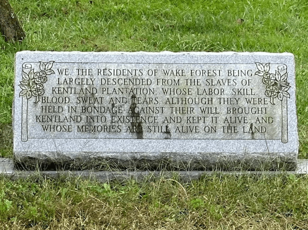
Following the Confederacy’s surrender in April 1865, the Kent family lost more than half of their wealth. Elizabeth, the eldest daughter, and Margaret, the youngest, along with the formerly enslaved individuals who stayed, struggled to rebuild their lives. Elizabeth took the lead, and although the exact details of the land transactions remain unclear, the freedmen eventually settled on 16 acres, forming the community known as Wake Forest.
Buchanans Bottom Renamed Kentland
After James R. Kent passed away on May 29, 1867, it took nearly 14 years to settle his estate. In the end, the sisters relinquished their interest in Buchanans Bottom to their youngest sister, Margaret Gordon Kent Cowan in 1882. In 1868, Margaret married Major John T. Cowan of Clarksburg, West Virginia.
Elizabeth remained at the house, managing the farm with the help of several freedmen. Before her death in 1884, she and Margaret renamed the property from Buchanans Bottom or River Farm to Kentland in honor of their father.

Boatmen
In the 1870 US census, Patricia Givens Johnson’s research (1995), and Montgomery County National Register of Historic Places 1989 application, the following African American boatmen moved people and goods on the New River: Jonathan Milton (b 1831), Frank Bannister (before the Civil War he worked the James River), Andrew Boon, John Brooks, James Price, Calvin Bannister, Roland Stuart, George Brown and Lewis Smith.

This is the 1925 version of the Montgomery County Map produced by W.F. Wall, Engineer. Note Cowans Mill and Whitethorn on the north side of the New River (red circle). A road is located on both sides of the river. This is the location where the boatmen would transport people, animals, & goods across the river. The the Virginian line train stop was at Whitethorn and Norfolk Western line stop was on the south bank of the river.
Wake Forest: Voices That Tell of a Faith Community, Cain, 2008. Courtesy of Christiansburg Institute Digital Archive
Books/Documents
- Department of Historic Resources (DHR) documents for the original 1991 application and the 2006 Slave Cemetery and prehistoric Late Woodland archeology documents.
- Walter Hubbard, Virginia Coal: Abridged History, 1990
- David E. Johnston, A History of Middle New River Settlements and Contiguous Territory, 1906.
- Patricia Givens Johnson, Kentland at Whitethorne: Virginia Tech’s Agricultural Farm and Families that Owned It, Blacksburg, VA: Walpa Publishing, 1995
- Linda Killen, These People Lived in a Pleasant Valley, 1996
- Mary B. LaLone, Appalachian Coal Mining Memories: Life in the Coal Fields of Virginia’s New River Valley, 1997
- Morgan Rochelle Cain, Wake Forest: Voices That Tell of a Faith Community. 2008. Courtesy of Christiansburg Institute Digital Archive
- Tonya Mosley, State Working to Close Jones-Keister Mine, Roanoke Times, 2008
- Zola Troutman Noble, Harmon
Oral History
- Esther Eaves Jones 2000 Oral History, transcription courtesy of Christiansburg Institute Digital Archives.
- Oral History with Esther Jones, November 9th, 2012 (Ms2019-037), Virginia Tech Special Collections, Tyler Bergeron, Interviewer
- Oral History with Charles Johnson, October 18, 2012 (Ms2019-037), Virginia Tech Special Collections, Ryan Noland & Katie Haas, Interviewers
General Resources
- Christiansburg Institute Museum & Archives (CIMA, scroll down to find their extensive archives)
- Freedman’s Bureau 1866-1868, Report of Charles S Schaeffer from the Virginia Counties of Montgomery and Pulaski, with additional information on the Floyd, Giles, Craig, Wythe, and Roanoke
Image Gallery